
They purchased a new Corvette and set out across the great USA in search of adventure and...I don't know...it was too early for all that hippy transcendental crap so just fun and chicks, I guess. Anyway, we watched them every week as they took odd jobs and met people who needed their help. I am sitting here hearing the theme song in my head; it was on the pop charts for a while...piano tinkling with a mellow backbeat, not the Bobby Troupe/ Rolling Stones song, just a mellow instrumental. Martin Milner and George Maharis were the guys, and the Corvette convertible was the co-star, a new one every season. For the last season or so Glenn Corbett took over as Marty's traveling companion. That was one of the lamest transitions in TV history but it was the sixties, so...Corbett came into the show as a troubled former Green Beret who, in his first episode, has a tussle with some small town teens and breaks a kid's wrist with a Karate chop. At some point in the dialogue he is challenged for not being remorseful about the kid, whose broken wrist pretty much finishes his hopes for a pro-basketball career ( again...sixties...).
Linc, Corbett's character, says he isn't sorry he broke the kid's wrist but he is sorry that he had to do it...hmmm...maybe not too soon for some hippy-thinkin'. Tod (Milner's character) and Linc have to have it out near the end of the episode and Linc promises it will be fair and square...he won't use his Karate Chop hands. They fight for a few minutes and it looks like Tod has the upper hand when Linc comes up into a stance with his "Karate Chop" hands...but then he hesitates for a second, resigns himself to the fates, makes fists out of his Choppers, and Tod whips his butt. So after that, Linc takes George Maharis' place and they drive off to the next little town and big adventure. It was cheesy, early sixties, and we loved it. The show was called "Route 66".
I can't help it; I have traveled on I 40 a dozen times and every time I remember the travels with the Chief in the our '55 Chevy, rolling down the old Route 66. That was one of the reasons I liked the TV show so much, I think, because we had been to a lot of those places. I-40 now covers a lot of the old highway but there are places where it is still visible...and usable in some cases. There is even a Route 66 Preservation Association or Committee or some such, dedicated to keeping the old route alive...or at least not buried. They sell memorabilia at every gas station and casino along the way. I keep forgetting to buy the route marker.
There is a Highway 80 preservation group, too. Just as 66 has been replaced with I-40, 80 has been mostly replaced by I-8. There aren't any glitzy souvenirs or tee-shirts at the gas stations like on 66, but 80 has always been "my way" more than 66. It just never had a TV show...or a jazzy song.
Driving down I-8 this month, I kept seeing parts of the old 80 and remembered how it used to be. In 1967 I drove my '65 GTO from San Diego to Fort Huachuca on my first solo trip out into the wilds of the desert. Just as I was leaving El Cajon there were two hitchhikers with a sign for Tucson. I started to pull over. I thought it would be a great way to pay for gas and have a conversation and then I saw they were both "heeled" as they used to say it the Old West, which meant they each had a pistol strapped on. So I re-thought how much fun I could have if I wasn't beat up or shot or had my car stolen and I punched the little GTO back up to Warp Speed and left the boys scratchin' their heads with one hand and waving at me with the other...you know...that old single-digit wave. That was the start.
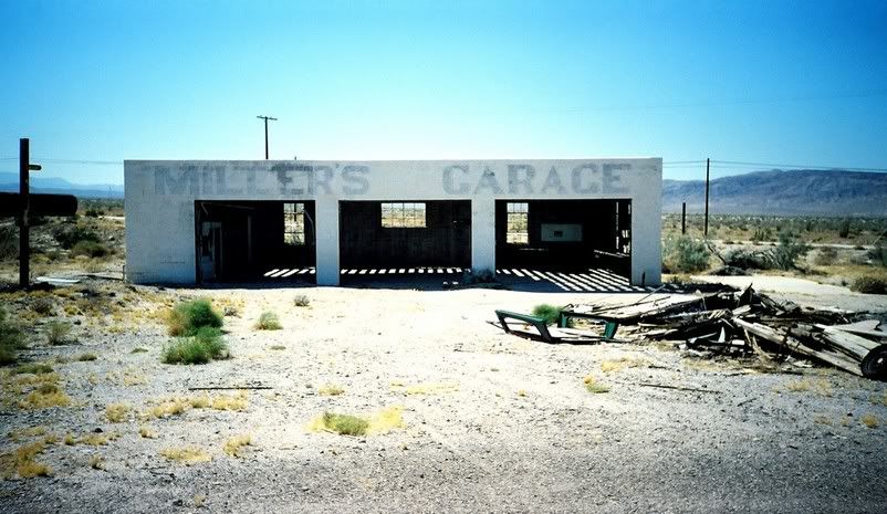
The mountains on the east edge of San Diego County look like big piles of rocks...big rocks. It was mostly two-lane in those days and for a few miles it wound back and forth across the county line so half the time you were in San Diego County and half the time in Imperial County. From the top of the grade you can see all the way to the haze over El Centro, it seemed. The highway dropped down out of the mountains towards the town of Ocotillo. Just before you got into town there were a series of roadside businesses. Today the remains of Miller's Garage is about all that is left there...and there is less and less of it all the time. I don't know if I ever stopped at Miller's, but I did stop at a couple of those roadside spots a time or two over the years. It was right on the edge of the Imperial Valley desert; it was hot and dry, always accompanied by bright, eye-stinging light. Down into the desert all you could see ahead was hot...lots of air-bending hot.
There is a stretch between El Centro and Yuma where there were these desert bushes, I don't know what they were (or are; they are still there, visible from the interstate) but they completely blocked the view on either side of the road. So it seems you had to drive down this bush canal forever...or to Holtsville, whichever came first. Now you look to the north and just a few yards away is the old highway and it is still lined with those bushes...but they don't seem as thick anymore; you can see through them.
Driving through Yuma was a tricky proposition; it is a Marine town, sort of, and was always a place for Californians to make donations to the Yuma City operating budget by way of traffic violations...real or imagined. Now the interstate loops around the town; good thing, too, 'cause Yuma is a lot bigger than it used to be.
The stretch of desert between Yuma and Gila Bend has a couple of mountain passes to go through and some windy low spots. After a buddy of mine got his Pontiac convertible stripped of the paint on its front fenders and hood and all the glass was frosted by a sandstorm in that same area, I watched the weather real close every time I had to pass through.
I remember on that first trip how much trouble I had with road- and lane-markers; the two-lane wiggled for no apparent reason, and it was dark...I mean DARK out there. I have already written a couple of times about night-driving woes, but with all the upgrades and technological improvements in the last 40 years, it is still very dark and very sleepy out on that desert.
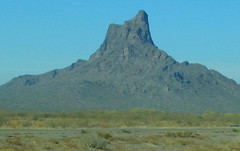
A lot of images from the many crossings I have made, either alone or with MC, stick with me: Seeing a mile-long freight train a half-a-mile north of the interstate keeping pace with me at 80 mph. Plaster City in full production-mode (Pre-EPA) with a white plume wafting across the desert and covering the old Highway with dust. ( The interstate runs about a mile south of the plant now and we didn't see any plaster dust this time, although everything in the town is still plaster white). The ruins of the roadside businesses along the old highway. Picacho Peak near Casa Grande looking as if forty years hadn't gone by, one of the few things that remained the same.
Highway 80 ran from the beaches of San Diego to somewhere back east. Before it was Interstate 8 it was referred to as the Broadway of the West, they say, but I never heard of it called that. It was just "80"...we used to say we were "going 60 down 80".